


Impacts of Roads on Wetlands and Waterbirds.
In the summer of 2001, considerable local debate took place over Busan City's proposal to construct (sometime within the next decade), a massive road-bridge over the inner part of the Nakdong estuary, one of the most important wetlands in South Korea for migratory bird populations. Following a series of consultations and meetings, the quasi-governmental expert body of the National Natural Monuments Committee surprised the city by rejecting the proposed road-bridge plan, and this decision was widely heralded as an example of significant progress in Korean wetland conservation.
However, soon after this announcement, Busan City then announced that they would indeed alter the plan, but only by shifting the bridge 300 meters northward. Busan city believed that an adequate political compromise had been achieved. The feeling still remains that Busan City, which has impressed the world with its successful hosting of several World Cup matches and the 14th Asian Games in 2002, is attempting to act in good faith and to solve massive road congestion problems that do exist. However, like so many other government authorities in South Korea and the East Asian region, they have been very poorly advised.
With the road-bridge construction still some years away, the following report is therefore reproduced here (one year after the debate) to encourage continuing discussion of the issue. The aim is not to embarrass or to challenge Busan city, but instead to present useful information on the anticipated impacts of the road bridge on the Nakdong estuary's already significantly disturbed eco-system.
At the same time, while preparing this (un-commissioned) report, we received very valuable information, given freely, from a wide range of experts in many countries on both specific and broader impacts on waterbirds of major construction adjacent to wetlands. Such information can surely enrich the decision-making process not only in the Nakdong, but in any similar developments throughout East Asia. Please therefore feel free to copy, quote or improve upon any of the information contained within….
The Miyeongji Road Bridge: a Preliminary Report on Anticipated Impacts
A response to a report produced for Busan City (anon, 2001 b).
Nial Moores
Introduction
The Nakdong estuary is one of the most important and better-studied waterbird habitats in South Korea and in East Asia. However, declines in diversity and numbers of waterbird individuals have been noted by many researchers, and such declines are considered to be continuing (e.g. Kim and Oh, 1994 etc).
The major historic cause of decline can be suggested to be the construction of a tidal barrage in 1987, with further and continuing declines occurring in response to piecemeal reclamation projects, the fragmentation of habitat, and increasing levels of disturbance. The most significant threat at present is the construction of a major 8-lane wide road bridge across the inner part of the estuary. This preliminary report is written for the benefit of NGOs, international experts, and most especially for consideration by decision-makers involved in the Miyeonji Bridge planning process (such as the National Natural Monuments Committee and Busan City officials).

This report aims to provide some background information and data to explain why increasing disturbance levels in particular are contributing to a continuing decline in diversity and numbers of birds in the Nakdong estuary. Contra the report produced by experts for Busan City, possibly in July 2001 (anon. 2001 b), strong evidence exists to show that disturbance caused both by the construction and end-use of the proposed Miyeonji Dae-Gyo (the Miyeonji Bridge) will cause significant negative impacts on the Nakdong estuary's migratory bird populations, most especially on the very locally distributed Taiga Bean Goose Anser (fabalis) middendorffi (and other specialized estuarine species), possibly causing a decline in the overall population of the taxon. Reference will also be made to examples in other countries, where roads have been shown to increase disturbance and negatively affect breeding and non-breeding densities of a wide-range of bird species.
Threatened in Korea by the Miyeongji Bridge Plan.
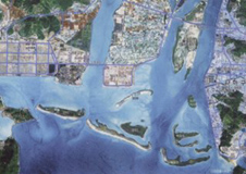
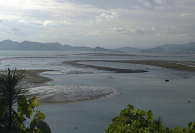
The Nakdong Estuary in southeastern South Korea (approximately 35 D 03 ` N, 129 D 10 'E) is one of the more-studied and more important wetland areas for waterbirds both nationwide and in eastern Asia. Research conducted especially in the 1980s and 1990s (e.g. Doornbos and Groenendijk, 1986; Hahm and Kang 1997; Kim, 1994; Piersma and Won, 1988; Won 1983 etc) suggests that possibly 36 species of waterbird have been recorded in internationally important concentrations with some 21 species still so supported in the late 1990s (Moores, 1999). Wintertime day peaks reached about 100 000 individual waterbirds in the 1980s, a little under 50 000 between April 1992 and April 1993 (Kim 1994), and 40 000 in the late 1990s (Pusan KFEM, 1997). Due to the asynchronous migration strategy of many of the species involved, however, it can be assumed that the actual number of waterbirds using the estuary throughout the year will be significantly higher than these peak counts due to turnover of migrants. Although such waterbird concentrations are significantly reduced compared to the mid-1980s, they still clearly identify the estuary as internationally important (i.e. more than 20 000 individuals regularly, and/or 1% or more of a known population of a waterbird), and therefore in need of conservation, in line with obligations under both the Convention on Biological Diversity and the Ramsar Convention. It is recognized by the Ramsar Convention (e.g. in the Montereux Guidelines) and in the broader wetlands conservation literature that the more diverse the wetland ecosystem, the more diverse the populations of waterbirds supported by it will tend to be. Waterbirds can be regarded as reasonable bio-indicators of wetland condition, as many species are specialized to a narrow range of conditions (e.g. Frazier, 1996). The exceptional number of species previously recorded in internationally important concentrations was indicative of the extremely diverse, broader Nakdong estuary eco-system. Major components of that pre-barrage estuarine/adjacent wetland system include:
Extensive freshwater areas (rice-fields, upstream freshwater ponds, marshes etc);
Extensive brackish areas (with a tidal reach of ca 38-41 km upstream of the barrage location, and historically throughout the estuary);
Extensive brackish/marine intergrade and marine areas (adjacent open sea areas);
Complex substrates and ecotones, with e.g. areas of reed-bed, sea-grasses, silt-rich muds and sandier outlier islands.
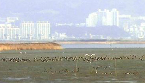
Following barrage construction, the estuary, despite its protected status, has been exposed to an increasing number of development projects, which have further fragmented the habitats and significantly lessened the complexity of the system. In particular the river above the barrage has been converted to an agricultural and industrial water source, and suffers severe eutrophication, more typical of a reservoir than a river (e.g. anon, 2001 a), while many upstream rice-fields have been converted to housing or other uses, reducing their attractiveness to feeding wildfowl. Most of the estuary water itself now tends to marine, except during heavy rain events when the barrage gates are opened, when the estuary then tends for several days to freshwater (e.g. anon. 2001a).
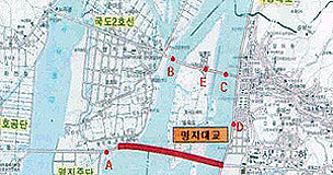
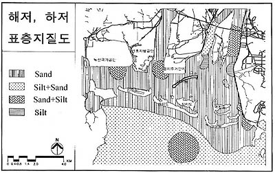
Within the estuary, the substrate is predominantly sandy, with six "patches" containing higher concentrations of mud, or sand-mud mix. These areas are located (1) west of Shinori (sand-mud mix); (2) west of Miyeonji (sand-mud mix); (3) between Miyeonji and Ulsook (mud, grading northwards to mud-sand); (4) east of Ulsook island (sand-mud mix); (5) southeast of Ulsook (mud); (6) southeast of the estuary near DadaPo (sand-mud) (p. 190, anon 2000 a).
The majority of complex substrates, typically associated in estuaries with higher concentrations of benthos and more complex plant communities can therefore be seen to be distributed in the Nakdong especially in the inner part of the estuary, most particularly adjacent to Ulsook Island and Miyeonji.
In addition, greater deposition loads adjacent to or in the main river-bed where it enters the estuary has led (as is typical in many estuaries) to the formation of small islands or elevated areas of tidal-flats (such as Ulsook Island and Miyeonji). Such areas maintain eco-system complexity by providing feeding areas later in the tidal cycle than lower areas (being inundated shallower and for shorter periods), and by providing safe roosting areas adjacent to the best feeding areas (thereby reducing birds' energy loss when moving between feeding and roosting areas).
Such a substrate distribution pattern is typical of many estuaries, and is often an important mechanism in influencing the distribution of vegetation and benthos, and therefore on those species of bird which depend on such vegetation or benthos for feeding. If no other major elements (such as disturbance) are present to influence distribution, it is probable that bird distribution can be reasonably predicted in the estuary through such a relationship. In South Korea many specialized waterbird species, including a significant percentage of Red-Crowned Grus japonensis, White-naped Grus vipio and Hooded Crane Grus monacha; most Black-faced Spoonbill Platelea minor; most geese; many swans; almost all Shelduck Tadorna tadorna; the majority of tidal-flat dependent shorebird species (especially Tringa, including Nordmann's Greenshank Tringa guttifer, but also calidrids such as Great Knot Calidris tenuirostris and several plover species) and all Saunders's Gull Larus saundersi typically occupy the inner part of the estuary, either for feeding or roosting or both. Such species are seldom supported by typically more exposed and sandy outer estuarine areas.
In addition, as intact inner estuary areas in Northeast Asia can be considered to represent a rare and threatened habitat type, most of these species are already listed as South Korean National Natural Monuments due to their localized distribution and poor conservation status, and are also listed as species of global Special Conservation Concern (e.g. by Wetlands International [2001] and Birdlife International [2001]).
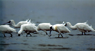
In the Nakdong, the favored loafing area of geese and swans is still on the elevated area of inner tidal-flat at Miyeonji (though used by a declining number of individuals), and many shorebirds used to feed on the tidal-flats at both Miyeonji and Ulsuk island, including up to 740 Great Knot in 1992-1993 (Kim, 1994), a very high count away from the Korean west coast.
Even as late as 1999, the largest concentrations (ranked in a category of "more than 500 individuals") of shorebirds were found in only three areas of the estuary: one, the main roosting area at Paekhap-Dung, the other two in feeding areas at Miyeonji (anon, 2000 b). The Nakdong's estuarine eco-system has already been largely simplified, and fragmented. The estuary is now largely marine for most of the year with sudden shifts in salinity towards freshwater in late summer stressing both fauna and flora, suggesting a likely mechanism for declines in the total numbers of individual waterbirds supported by the estuary and for loss of some waterbird and at least fish diversity from the system (e.g. anon., 2001 a).
Generally, within estuaries the brackish zone is often associated with very high productivity (if even by a relatively few, often highly specialised species), able to support large concentrations of birds. Moreover, within the brackish estuarine zone, until the late 1980s, there were ca 9 560 ha of wetlands, with numerous tidal-channels, low-lying islands and sandbars and about 3 000 ha of tidal-flats (Piersma and Won, 1988). However, subsequent opening up of the estuary to development has led to several wetland conversion and reclamation projects (leading to a direct loss of at least 330 ha of wetland area), and modification of the wetland/land interface, through the construction of sea-walls etc.
Examples include Ulsuk Island, which became connected to the mainland through the barrage bridge, with part converted for use as a waste disposal landfill, while parts of the Shinori and Miyeonji tidal-flats and much of the estuary's eastern flank have been reclaimed for housing and industrial estates.
In the case of Ulsuk Island, a relatively undisturbed complex system of tidal channels and flats (pre-barrage) has been converted (post-barrage) to largely dry farm land with remnant reed beds and increasingly disturbed tidal-flats, supporting a now impoverished bird fauna.
In recognition of the loss of diversity and wetland function, Busan City commissioned a basic restoration plan for Ulsuk Island from Pusan National University in 2000/2001. This plan emphasized the need to recreate wetland habitats, reduce disturbance through the establishment of buffer and core areas, and aimed to restore some of the populations of several key target species that should be present within the brackish zone (anon. 2001 a). Reclamation at Shinori and Miyeonji has led to a direct loss not only of intertidal areas but also of some of the estuary's zostera eel-grass beds, reducing the available area of vegetated tidal-flat and sub-tidal areas for feeding and loafing geese and swans.
Species that have shown marked declines not surprisingly include the highly specialised and localized Black Brant Branta nigricans, which often feeds on zostera. The species declined from 700-840 individuals in 1984 (Won and Hahm, 1984) to 16 in 1996 (anon., 1997), and less than 10 in subsequent winters. The Black Brant, with an estimated population of only 5000 individuals in East Asia (subspecies orientalis: Rose and Scott, 1997) is found regularly at only one or two sites nationwide (where it can be extremely wary and difficult to approach), and even though some zostera beds remain the species has been effectively lost from the Nakdong, largely due,we believe, to increased disturbance of remaining areas.
Disturbance
Three terms need to be defined in a discussion on disturbance of waterbirds: disturbance itself, disturbance impact as opposed to disturbance effect; and disturbance distance. Disturbance can be defined as "any relatively discrete event in time that disrupts ecosystems, communities or populations" (Cayford 1993); disturbance effects as local site movements and disturbance impacts where a population is affected (Hill et al, 1997); and disturbance distance, (an important element to factor in when predicting the distance at which e.g. roads will cause disturbance to birds), as the distance at which "human activities cause a bird to behave differently from the behaviour it would exhibit without the presence of that activity" (Oranjewould, 1982).
The main disturbance factors within the estuary at present include fishing-related activities (e.g. anon, 2001 b) and the increasing urbanization of adjacent areas. Such disturbance factors would, perhaps, be less significant if they were localized or if the birds had alternative areas to move to. However, the loss of other estuaries through damming and reclamation, the extent of habitat loss surrounding the Nakdong estuary itself and through reclamation within it, have substantially reduced the options for waterbirds, and increasing disturbance is compounding already existing stresses.
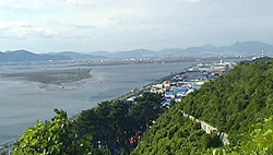
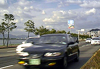
Since the late 1980s, intensive development has taken place along the northern and eastern flank of the estuary, so that buildings and roads illuminate the skyline at night. At Shinori and Miyeonji, recent reclaimed areas are being given over to housing, and the construction of several brightly lit `love hotels' has already taken place. The road from Miyeonji to Shinori has been built wide, in preparation for the proposed Miyeonji Bridge, for the most part in clear view of the estuary.
The impacts of such development will affect different species and even different individuals of the same species differently, with some species and individuals habituating more efficiently to the disturbance than others. A Review of Disturbance Impacts of Roads on Birds (Ecoscope, 2000) concluded, on a review of over 100 published papers that, in general...(the species) most vulnerable to disturbance and development impacts (are):
large species;
long-lived species;
species with relatively low reproductive rates;
habitat specialists;
species living in open (e.g. wetland) rather than closed (e.g. forest) habitats;
species using traditional sites;
species whose populations are concentrated in a few key areas.
In the case of the Nakdong estuary, species which have shown the greatest declines include many shorebirds (sensitive to reclamation and disturbance of key feeding and roosting areas), and especially, larger species such as White-naped Cranes Grus vipio, Greater White-fronted Anser albifrons frontalis and Taiga Bean Geese Anser (fabalis) middendorffi, which meet all of the criteria postulated by Ecoscope above.
In addition to declining numbers or loss to the estuary of a regular over-wintering population (as in the case of the White-naped Crane), the distribution of several such species is believed by Woo (anon., 2001 b) to be changing, with a gradual movement by many species away from inner estuary areas to more remote outer parts of the estuary. However, contra Woo (anon, 2001 b) the suggested cause of this change in distribution is rather more likely to be a response to increasing disturbance and not due to the creation (through sediment deposition) of better, new feeding areas. The report fails to provide supporting evidence for this supposition, and does not refer to extensive literature describing disturbance effects/impacts on waterbirds elsewhere in estuaries and other habitat types.
Although requiring more detailed research, the outer part of the Nakdong estuary now appears to be supporting an increasing number of shorebirds and other waterfowl in areas that can probably be considered sub-optimal (especially when compared to previously preferred inner estuary areas), for the following reasons:
The outer areas have generally sandy substrates (thus in probability supporting less complex assemblages of fauna and flora);
They are more exposed to wind (requiring an increase in food intake to balance energy lost through increased thermoregulation expenditure);
Food intake itself will be made more difficult due to increasing "interference" (e.g. Goss-Custard 1989, Goss-Custard & Durrell 1990) caused by higher densities of birds in an ever-decreasing area of used estuary/adjacent rice-field;
The distance from feeding and loafing/roosting areas has been increased for many Anatidae that feed predominantly in rice-fields or river-based feeding areas, also demanding higher food/energy intake.
The ongoing declines or loss of several species from the Nakdong estuary are therefore likely to be caused by a number of interrelated factors already outlined above, especially habitat loss and habitat degradation, further exacerbated by increasing disturbance levels.
The Proposed Bridge and Disturbance by Roads
In consideration of the Miyeonji Road bridge, which Busan City proposes is an essential infrastructure improvement, it is perhaps most important to consider:
Whether the bridge will cause disturbance impacts, rather than temporary, reversible disturbance effects (the former causing non-compliance with the obligations and articles of e.g. the Ramsar Convention);
If it will cause disturbance impacts, what will they be,
How to mitigate or at least reduce such impacts.
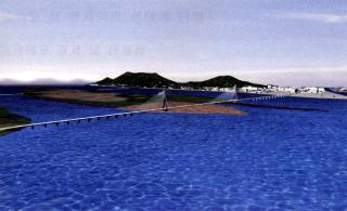
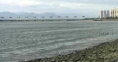
The proposed Miyeonji Bridge will be 3.2 km long (with an additional 1.6 km of links and slip-roads); it will be 35 m wide (with 8 lanes); it will have an average height of 15-20 m, though rising to 80 m at Ulsuk Island if a suspension system is adopted; and it will be built to carry some 93 600 vehicles per 24 hours. Traffic will consist of a variety of vehicles, including trucks.
This design is apparently preferred by a leading professor at Kyongsong University, Busan, as, in his opinion, it will not cause significant disturbance to waterbirds or their habitat.
The bridge's western slip road (not shown) will cut across the presently favored loafing area of the Taiga Bean Geese, and traverse both the most complex substrate areas of the inner estuary and reed-bed areas at the southern end of Ulsuk Island. This will lead to the direct loss of habitat used by several waterbirds, as well as concentrating disturbance elements in areas adjacent to the most sensitive areas presently used by birds. Channels for fishing boats will remain open, with one main channel running under the bridge, then between the seawall (with present car parking area and an increasing number of buildings) and the main loafing area at Miyeonji, adding extra irregularity to noise levels ("the startling effect", e.g. Hockin et al. 1992).
As proposed, the noise level from the bridge alone is predicted to be between 63-75 dB, with an average 70 dB at 100m, 62 dB at 200 m, and 58-59 dB at over 500 m range (anon, 2001 b).
Few specific studies appear to have been conducted in South Korea, but research conducted elsewhere (especially in Europe, with synopses provided to WBK by Ecoscope, UK) suggest that roads can and do cause considerable negative impacts on a variety of bird species.
Although vehicles and vehicle movements are tolerated much better than people at the source of disturbance (Hockin et al, 1992), disturbance caused by roads is related to traffic volume, layout of the road, carriageway size and hence scale and adjacent habitat types (Ecoscope, 2000).
In the Netherlands, studies on Willow Warblers Phylloscopus trochilus and other woodland species showed a negative impact of roads on density of 26 woodland bird species out of 43 analysed, with effects measurable from 40-1500 m from roads with 10 000 cars per day, to 70 m to 2 800 m from a road with 60 000 cars per day (Reijnen & Foppen 1994, Foppen & Reijnen 1994, Reijnen et al 1995).
In another study (in Ecoscope, 2000) in the Netherlands on species occupying more open grassland habitat, 7 species studied showed a reduced density adjacent to the road. Disturbance distances varied between species, ranging from 20-1700 m from the road at 5000 cars per day and 65 m to 3530 m at 50 000 cars a day. At 5000 cars a day most species had an estimated population loss of 12-55% within 100 m of roads; at 50 000 cars per day all species had estimated losses of 12-52% up to 500 m, while some (including three species of nesting shorebird) had populations reduced by 14-44% up to 1500 m away from the road.
Another study, in Canada by Findlay and Houlahan (1997) studied the relationship between road construction and road density and bird species, and found a distinct negative correlation of bird species richness and road density within 2 km of a wetland. In the case of non-breeding waterbirds, disturbance has been shown to displace ducks, geese and shorebirds from preferred feeding or roosting areas in winter (Tuite et al 1983, Galhoff et al 1984, Bell and Austin 1985 etc) or to cause the complete abandonment of areas (Putzer 1983, Bell and Austin 1985, Korschgen et al 1985, Burger 1986). A shift from preferred to less preferred feeding areas is likely to affect feeding efficiency; this has shown to be the case for gulls feeding on mudflats (Burger 1988). Owens (1977) also studied the response of Brent Geese Branta bernicla to disturbance: areas with poor visibility and proximity to traffic were avoided until other areas had been depleted of food, suggesting that such sites, once favored, become sub-optimal. Energy intake needs to be balanced against energy requirements caused by increased flying time and time spent watching and listening for predators rather than roosting or feeding etc. In the case of specialist species, sub-optimal feeding and roosting conditions can lead both to higher mortality in winter and also reduced breeding success in summer (e.g. Davidson and Rothwell, 1993). This displacement and species' loss/decline already appears to be taking place in the Nakdong estuary, as outlined above.
Three other studies reviewed by Ecoscope showed that wintering geese avoided areas close to roads (Mooij 1982, Madsen 1985, Keller 1991), with greater distance required from more heavily used roads, while windbreaks and banks which hinder an open view reduced use of land by geese up to 200-300 m from such structures.
In Japan, where the same species and subspecies of birds as in the Nakdong estuary have been researched, there are many examples of "lost goose populations because of their habitat being divided up by roads" (Kurechi, in lit, on which the following paragraph is also based).
For example, Fukudamachi in Sendai City, used to be one of the two biggest wintering areas in Japan for Greater White-fronted Geese. However, following the construction of the 4-lane wide National Route 4 through the middle of their feeding area, the geese soon deserted this traditional site (Primack & Kobori, 1997).
In addition, according to extensive research by Anatidae experts, the construction of a bridge across wintering sites leads to the loss of use of areas near the bridge.
Height is considered a key factor in determining the distance at which the structure itself is considered to be a major disturbance element. It is suggested, based on such Japanese examples, that a 100 m tall structure will create a disturbance distance of 1000-1800 m both sides of a bridge (leading to potential loss of a corridor of habitat more than 3.5 km wide) for geese and swans. There are no precise studies yet found relating to the disturbance distance to waterbirds of a bridge in Korea 20 m high, reaching 80 m at highest, with constant lines of moving vehicles and lights, but it can be supposed that the distance for geese will be considerably further than the 200-300m found in response to relatively low, and immobile structures, and in probability closer to the 1800 m suggested in Japan (considering the width of the road, the volume of traffic, and the combined effects of other disturbance elements).
In South Korea too, there are also very few examples of White-naped Cranes, Hooded Cranes, Taiga or Tundra Bean Geese Anser (fabalis) serrirostris or Greater White-fronted Geese feeding or roosting close to major expressways or bridges.
Almost all sites occupied by such species appear to have significantly below average disturbance levels (e.g. in the DMZ, in extensive tidal salt-marsh near Kanghwa Island or in Suncheon Bay etc), and within the DMZ, where the very restricted traffic flow consists almost entirely of agricultural vehicles, research showed that neither White-naped nor Red-Crowned Cranes used fields within 500-700 m of paved roads (Bae, 2000).
One exception appears to be the Han-Imjin River near to the North Korean border, where both geese and White-naped Cranes can sometimes be seen within 250 m of a main road. Major differences between the Han River and the Nakdong estuary, however, include:
A tall fence alongside the road constructed by the army to prevent access by spies and hostile soldiers, which also prevents any other human access either to the river or to preferred feeding and roosting areas;
The Han river is very wide and shallow with abundant emergent vegetation and undisturbed rice-fields between it and the road offering many refugia from disturbance;
A complete lack of boat traffic.
Though more research is required even at the Han-Imjin estuary the majority of the more sensitive species appear to prefer feeding or loafing in areas much further removed from the road itself, with Tundra Bean Geese and Greater White-fronted Geese only feeding closer (especially on the southern, sunlit bank down from the road towards the river) during periods of severe cold and snow cover.
Moreover, as car traffic and other disturbances in the area have increased along with habitat degradation, several of the more sensitive species, such as White-naped Cranes, have declined.
Other apparently tolerant species found at the Han-Imjin in winter and next to main roads in Seoul include the widespread Mallard Anas platyrhynchos, Pochard Aythya ferina and to a lesser extent the Goosander Mergus merganser orientalis.
These species are cited (anon., 2001 b) as evidence that the Miyeonji Bridge will not cause an impact, but it is rather probable that many such individuals are also likely to be occupying sub-optimal areas, as the majority of rivers and waterbodies in the region become frozen in mid-winter, leaving very few feeding areas available to birds.
Even so, the Han River in central Seoul has a broad park edge, and the majority of such individuals appear to remain in/near the centre of the river, 200 m or more from the road itself.
Noticeably, swans, geese and cranes are completely absent from such heavily-developed areas.
In the report produced for Busan City (anon., 2001 b), information on wetlands and roads in other countries seems to suggest that the Miyeongji Bridge will not cause major impacts to birds. However, much of this information appears to be based on a misunderstanding of the sites referred to and a lack of understanding about the impacts of disturbance.
Such examples appear to be misleading and do not help to assist the City in making the most appropriate choices in relation to the Myeonji Bridge and infrastructure problems.
In Japan, where geese are especially well-studied, there are no cases known where Taiga Bean Geese can be found next to expressways (Miyabayashi 1994), suggesting a negative correlation, but making it more difficult to assess possible impacts of future road construction projects on the species (Miyabayashi in lit).
However, Tokyo Bay previously supported very large concentrations of geese and other Anatidae: all the geese populations have now been lost (with no displacement elsewhere in the flyway of species such as Greater Snow Goose Anser caerulescens and Canada Goose Branta candensis) and probable declines in overall populations of those species which still remain, (due mainly to hunting (in the late 19th century), then habitat loss and degradation and increased disturbance).
Also, contra the report (anon, 2001 b) that suggests that "geese and other migratory birds have occurred since the 1960s" at Gyotoku Wild Bird Park, geese (Greater White-fronts) in fact "disappeared from Gyotoku in the middle of the 1960's and never came back." (Kurechi in lit).
The lack of geese (or cranes etc) in Tokyo Bay alone renders the use of examples of Gyotoku Bird Park, Tokyo Wild Bird Park and Yatsu tidal-flat as inappropriate for comparison with the Nakdong estuary. In fact it suggests that a Tokyo Bay style development of roads and bridges (such as the Miyeonji Bridge) will actually lead to the loss of such species from the Nakdong estuary.
Moreover, none of these sites even support any shorebirds (on updated criteria) or Anatidae in internationally important concentrations, and Tokyo Bay itself can be considered to support "quite degraded biodiversity now" (Miyabayashi in lit), supporting only one species of Anatidae, the Great Scaup Aythya marila mariloides in internationally important concentrations (Miyabayashi and Mundkur, 1999).
In addition, although Yatsu tidal-flat is a Ramsar site, and, through the efforts of local people, the Wild Bird Society of Japan and local government, it plays a very important role in environmental education, Yatsu does not support any species of waterbird in internationally important concentrations nor does it or the other Tokyo sites referred to (anon. 2001 b) regularly support any species of Special Conservation Concern.
Careful planting and screening of the site though, as at Gyotoku and the Tokyo Wild Bird Park, has improved the visual appearance of the site for visitors and helped to reduce disturbance levels to allow continued usage by a limited range of comparatively tolerant species. Such screening and usage should be used as examples to show the need for and benefits of reducing disturbance levels in the Nakdong, rather than increasing them, and of involving the local community in efforts to conserve key areas of habitat for waterbirds.
Another example cited, that of the Severn Estuary Bridge in the UK, also seems highly inappropriate.
The Severn estuary is much longer and wider than the Nakdong estuary. It has significantly more than the "1 400 ha of tidal-flats" suggested (anon, 2001 b), containing no less than three Ramsar sites (The Severn estuary proper, at 24 701 ha; the Upper Severn at 1 357 ha; and Bridgewater Bay at 2 703 ha [Ramsar home-page, List of Sites of International Importance]), and several areas specifically managed for waterbirds, such as the Slimbridge Wildfowl and Wetlands Trust Reserve.
Although the Severn Bridge can be said to be located in a broad area of high value to waterbirds, the bridge itself is not located in an area much used by e.g. shorebirds (e.g. Clark 1990, in Bibby et al. 2000), which instead especially favour Bridgewater Bay (an area largely lacking infrastructure).
In addition, the majority of the Severn Estuary's geese congregate at the Slimbridge WWT reserve, where management practices include sward management and strict controls on disturbance, so ensuring adequate food and secure roosting.
The possible impacts of the Miyeonji Bridge cannot be deduced from such an example, but again, the Severn Bridge offers a valid model in trying to balance the needs of development and infrastructure improvements without compromising wildlife values. It is necessary to construct bridges in areas with comparatively low wildlife value, where effects can be adequately mitigated, and to manage key areas for conservation.
The Delta barrier road in the Netherlands referred to (anon., 2001 b) is also an erroneous example. The road carries little traffic compared to the 93 600 cars a day proposed for the Miyeonji Bridge, and the area supports no internationally important concentration of birds.
Studies elsewhere in the Netherlands, however, referred to above, clearly conclude that roads in that country, as elsewhere, do have a serious negative impact on bird populations.
This conclusion and the results of studies conducted in the Netherlands should be used for predicting possible impacts of the bridge construction.
The Suggested Impacts of the Proposed Bridge
The Miyeonji Bridge as proposed will be a very large and busy road, creating major obstruction to the horizon in a very open and sensitive habitat, in and adjacent to areas that presently support internationally important concentrations of species already considered in regional (i.e. flyway-wide) decline.
Already declines in several more sensitive species are taking, or have already taken, place within the estuary at rates apparently higher than that experienced outside of the estuary or elsewhere in the flyway (e.g. Taiga Bean Goose, Greater White-fronted Goose, Black Brant, Common Shelduck, White-naped and Hooded Cranes, Eurasian Numenius arquata orientalis and Far Eastern Curlew Numenius madagascariensis, Great Knot, Red-necked Stint Calidris ruficollis and Spoon-billed Sandpiper Eurynorhynchus pygmeus.).
This suggests that the estuary's waterbird populations are already severely stressed by a combination of unfavorable conditions. Moreover, several of these species have very localized distributions within Korea or even globally due to similar habitat loss, degradation and increasing levels of disturbance in many coastal regions of East Asia.
In the case of the Taiga Bean Goose, the species in South Korea is near-confined to three sites (Upo, Joonam and the estuary), all within the Nakdong river system, with individuals shared between the three sites, moving from one to the other in relation to disturbance and food availability (Park, 1993 ).
More specialized for feeding on aquatic plants than either Tundra Bean Geese Anser (fabalis) serrirostris or Greater White-fronted Geese, the Taiga Bean Goose is especially vulnerable to changes in preferred wetlands. Declining suitability of habitat and increasing disturbance especially at Joonam and in the Nakdong estuary means that the population now stands possibly at ca 4 000 individuals (NB: data is still being requested), down from 6 000 in the late 1990s, a downward trend not matched in neighboring Japan (where the Taiga Bean Geese population is either stable or showing a slight increase: Kurechi M. pers. com.).
This suggests strongly that the decline in the Nakdong population is being caused by changes in the suitability of local non-breeding areas rather than of the breeding areas.
Although further research is necessary, it is probable that disturbance and increasing competition for dwindling food supplies in the non-breeding areas has indeed led to both higher mortality in winter and also reduced breeding success in summer (e.g. Davidson and Rothwell, 1993), ultimately reducing overall population levels.
Assuming that the geese (and other species such as swans and cranes) will not be able to use areas within a highly conservative estimate of ca 500 m of the bridge (probably being effected over a considerably greater range, up to or even in excess of 1800 m), due to noise, movement, and lights, this suggests that the majority of preferred feeding and roosting areas in the estuary would be lost to the species. Considering the lack of alternative sites able to support the already declining population outside of the estuary, it would seem appropriate to conclude that the proposed bridge would create significant disturbance impacts rather than mere short-term effects.
Considering too the proposed location of the bridge, it would also suggest that most inner estuary preferential waterbird species would be similarly affected and would suffer further declines.
In addition future restoration and habitat management efforts e.g. at Ulsuk island, aiming to restore population levels to pre-barrage construction levels would become even less likely to succeed.
The increase in disturbance caused by the proposed road bridge will occur:
during construction (especially noise, and visual disturbance including lights);
in the form of the structure itself, considering that most geese and shorebirds avoid structures that prevent them from seeing the horizon and potential predators;
through end-use.
Additional possible problems from the present proposed design include an increase in pollution during construction and more significantly an increase in both water and air pollution in the estuary itself by vehicles. Run off from the road direct into the estuary during rain events, combined with pollutant loads from storm drains constructed on recently reclaimed land adjacent to the Miyeonji tidal-flat, is likely to create problems for the estuarine vegetation and for fish and shellfish.
To reduce disturbance effects/impacts on waterbirds the bridge design has to consider not only existing bird behaviour (as suggested by anon., 2001 b and the reference to waterbird movement), but also both historic and likely future use.
Although a very high bridge might allow waterbirds to maintain sightlines of the horizon, it is more probable, based on research in Japan, that the taller the structure the larger the probable impact on key waterbirds species in the Nakdong, as e.g. geese, cranes and even swans appear to be especially sensitive to visual disturbance elements.
It is therefore strongly suggested that a design incorporating a low structure, extensive screening, constructed across/through less sensitive areas, will be essential if waterbird populations are not be significantly impacted.
Within the Nakdong estuary, the only reasonable option is to widen existing roads, so that the traffic flow goes across the existing barrage. However, greater efforts also need to be expended in reducing increasing disturbance from the existing road, even before widening, with strictly imposed limits for building and building heights, zoning to reduce access to the most sensitive areas, and more consideration given to the creation of valid buffers or sound screens.
Summary
In common with other NGOs and individuals, we repeat the opposition to the proposed Miyeonji Bridge on environmental grounds.
Encouraged by the City's very open and responsible attitude, which includes the recognition that the Nakdong estuaryis an important natural resource, and that the bridge planning process must be negotiated at all stages with NGOs, experts and local people, we have opened up information on the project to a variety of leading international experts through the internet, by mailing and by discussion at site.
This is especially because we believe that the City and the national government both recognize and value the international importance of the Nakdong estuary for waterbirds, and therefore wish to comply with the obligations held under the Convention on Biological Diversity and e.g. Article 2.6 and Article 3.1 of the Ramsar Convention, whereby "Each Contracting Party shall consider its international responsibilities for the conservation, management and wise use of migratory stocks of waterfowl", and each Contracting Party shall "formulate and implement...planning so as to promote...as far as possible the wise use of wetlands in their territory."
Our response contained in this preliminary report is based on our own research combined with information provided by such independent international expert opinion.
We repeat, our interpretation of existing data and studies suggests very clearly that the Miyeonji Bridge as proposed will cause significant negative impacts on the estuary's migratory waterbirds.
We believe that to proceed with the bridge would show lack of consideration for international responsibilities to conserve migratory waterbirds, and that such a Bridge contradicts planning aimed at wise use of wetlands in South Korea.
We reaffirm that if the road infrastructure needs to be improved, then the road needs to be created through a widening of existing roads alongside the estuary and across the existing barrage, and not through the creation of a bridge across the most sensitive and diverse parts of the estuary.
We also affirm that greater efforts must be made to prevent further declines in waterbirds and the population of other biota (including River Otter Lutra lutra) if the estuary is to eventually fulfill its role of providing a world-class "natural", environmental, and recreational resource in one of South Korea's largest and leading cities.
Irrespective of whether the bridge is built or not, greater efforts must be made, through the cooperation of NGOs, other experts, stakeholders and decision-makers, to promote public awareness of the value and international importance of the estuary, and to develop a Nakdong Master Plan for Conservation which genuinely achieves sustainable and equitable use.
With the utmost respect,
Nial Moores.
Acknowledgements
We would especially like to thank Ecoscope UK Environmental Consultants for their many contributions and their correspondence with e.g. the Ramsar Bureau and Wetlands International in relation to this proposed project;
Miyabayashi Yoshihiko (Chair of The East Asian Anatidae Working Group) and Kurechi Masayuki, President of the Japan Wild Goose Protection Association, who reviewed the project plan and provided several extremely important examples from Japan;
and George Archibald of the International Crane Foundation.
All contributed significantly to the paper and to our understanding of the issue.
References
- Anon. (1993). Migratory Birds on the Sanbanze: Status and Short-term movements. Educational pamphlet produced by Friends of the Gyotoku Wildbird Preserve.
- Anon (2000 a). Report of Basic Plan for Management of the Nakdong Estuary. 862 pp. Produced under the auspices of Busan City (in Korean)
- Anon (2000 b). Report of Basic Plan for Mangement of the Nakdong Estuary. Produced under the auspices of Busan City: Bird section ca 26 pp ( in Korean).
- Anon (2001 a). Ulsuk Island Basic Basic Plan for Ecological Park (produced in Korean by Pusan National University Limnology Department for Busan Metropolitan City)
- Anon (2001 b). Short Report on Miyeonji Bridge Proposal, with many references to birds, disturbance and international examples. Produced under the auspices of Busan City, possibly July 2001. (in Korean). Proper reference still being sought.
- Bae, S-H (2000). A study on Habitat Use of Wintering Cranes in DMZ, Korea. With Carrying Capacity and Spatial Distribution Analysis Using GIS. Phd Thesis, Kyung-Hee University.
- Bell, D.V & L.W. Austin. (1985). The game fishing season and its effects on overwintering wildfowl. Biological Conservation, 33, 65-80.
- J., Burgess, N.D., Hill, D. & S. Mustoe (2000). Bird Census Techniques, Second Edition. Academic Press.
- Birdlife International (2001) Threatened Birds of Asia: the Birdlife International Red Data Book
- Burger, J. (1986). The effects of human activity on shorebirds in two coastal bays in north eastern United States. Environmental Conservation, 13, 123-130.
- Burger, J. (1988). Effects of demolition and beach clean-up operations on birds on a coastal mudflat in New Jersey, USA. Estuarine, Coastal and Shelf Science, 27, 95-108.
- Cayford, J. (1993). Wader disturbance: a theoretical overview. Wader study Group Bulletin 68: 3-5.
- Davidson, N.C & P.I. Rothwell. (1993). Disturbance to waterfowl on estuaries: the conservation and coastal management implications of current knowledge. Wader Study Group Bull. 68: 97-105.
- Doornbos,G. & A.M. Groenendijk. (1986). Nakdong estuary barrage and reclamation project. Preliminary results of the botanical, macrozoobenthic and ornithological studies. Biological Conservation 38: 115-142.
- Ecoscope 2000. Review of Disturbance Impacts of Roads and Birds.
- Findlay, C.S. & J. Houlahan. (1997). Anthropogenic correlates of species richness in southeastern Ontario wetlands. Conservation Biology 11, 1000-1009.
- Frazier, S. 91996). An overview of the world's Ramsar sites. Wetlands International Publication 39.
- Findlay, C.S. & J. Houlahan (1997). Anthropogenic correlates of species richness in southeastern Ontario wetlands. Conservation Biology, 11, 1000-1009.
- Foppen, R. & R. Reijnen (1994). The effects of car traffic on breeding bird populations in woodland. II. Breeding dispersal of male Willow Warblers (Phylloscopus trochilus) in relation to the proximity of a highway. Journal of Applied Ecology, 31, 95-101.
- Galhoff, H. Sell, M. & M. Abs (1994). Aktivitatsrhthymus, Verteilungs-muster und Auweichfluge von Tafelenten Aythya ferina L. in einem nortwestdeutschen Ueberwinterungsquartier (Ruhrstausee Kemnade). Anz. Orn. Ges. Bayern, 23, 133-147.
- Goss-Custard, J. (1989). The Effect of Loss of Intertidal Habitats on Shorebird populations. IWRB News 1: 8-9.
- Goss-Custard, J. & S. Durrell. (1990). Bird Behaviour and environmental planning: approaches in the study of wader populations. Ibis 132: 273-289.
- Hahm, K.H. & J-H Kang. (1997). Nine year records of Waterbirds in the west Nakdong River (1988-1996). Bulletin of the Korean Institute for Ornithology. Vol. 6 No.1: 35-45, 1997.
- Hill, D., Hockin, D., Price, D., Tucker, G., Morris, R. & J. Treweek. (1997). Bird disturbance: improving the quality and utility of disturbance research. Journal of Applied Ecology, 34, 275-288.
- Hockin, D., Ounsted, M., Gorman, M., Hill, D., Keller, V. & M. Barker. (19920. Examination of the effects of disturbance on birds with reference to the role of environmental impact assessment. Journal of Environmental Management, 36, 253-286.
- Keller, V. (1991). The effect of disturbance from roads on the distribution of feeding sites of geese (Anser brachyrhynchus, A. anser) wintering in northeast Scotland. Ardea, 79, 228-231.
- Kim, H-C & P-O Won (1994). Ecology of Waterbirds in the Nakdong Estuary, Korea (fuller reference still being sought)
- Korschgen, C.E., George L.S. & W. L Green (1985). Disturbance of diving ducks by boaters on migrational staging area. Wildlife Society Bulletin 13, 290-296.
- Madsen, J. (1985). Impact of disturbance on field utilization of Pink-footed Geese in West Jutland, Denmark. Biological Conservation, 33, 53-63.
- Miyabayashi, Y. (ed.) 1994. Inventory of goose habitat in Japan. First edition. JAWGP, Wakayanagi, Japan, 316pp. in Japanese with English summary
- Mooij, J.H. (1982). Die Auswirkungen von strassen auf die Avifauna einer offenen landschaft am Unteresn Niederrhein (Nordhein-Wastfalen), untersucht am Verhalten von Wildgansen. Charadrius, 18, 73-92.
- Moores, N. (ed.) National NGO Wetlands Report: Ramsar 1999.
- Owens, N.W. (1977). Responses of wintering Brent Geese to human disturbance. Wildfowl, 28, 5-14.
- Park, J-Y. (1993). Ecology of Bean Geese and White-fronted Geese at Joonam Reservoir. (fuller reference still being sought)
- Piersma, T. & P.O Won. (1988). Extract on the Nakdong Estuary, in The Asian wetlands Directory (D.Scott, 1988).
- Primack, R. & H. Kobori (1997). The Primer of Conservation Biology, Bunnichi Sogo Shuppan, Tokyo., 1997: 124-125.
- Pusan KFEM (1997) Report on waterbirds in the Nakdong estuary (in Korean).
- Reijnen, R. & R. Foppen (1994). The effects of car traffic on breeding bird populations in woodland. I. Evidence of reduced habitat quality for Willow Warblers (Phylloscopus trochilus) breeding close to a highway. Journal of Applied Ecology, 31, 85-94.
- Reijnen, R. Foppen, R., Ter Braak, C. & J. Thissen (1995). The effects of car traffic on breeding bird populations in woodland. III. Reduction of density in relation to the proximity of main roads. Journal of Applied Ecology, 32, 187-203.
- Rose, P.M. & Scott, D. A. 1997. Waterfowl Population Estimates. Second Edition. Wetlands International Publication 44. Wageningen, The Netherlands.
- Tuite, C.H., Owen, M., & D. Paynter (1983). Interaction between wildfowl and recreation at Llangorse Lake and Talybont reservoir, South Wales. Wildfowl, 34, 48-63.
- Wetland International Asia-Pacific. (2001). Asia-Pacific Migratory Waterbird Conservation Strategy: 2001-2005).
- Won, P.O. (1983). Bird populations in the Nakdong estuary. These collection, Kyung Hee University, Seoul. 12: 67-84.
- Won, P.O & K.H. Hahm. (1984). Nakdong river estuary and Joonam Reservoir in the southeastern part of the Korean peninsula. Theses collection, Kyung Hee University, Seoul, Korea. 13: 99-117.